Solano County has lots
to offer in the great outdoors! Below is information and links
for our
favorite Solano County locations. We hope you'll come visit!
|
 |
Al Zampa Memorial Bridge (Carquinez
Bridge) Bicycle & Pedestrian Path
Interstate 80 (westbound)
Vallejo, CA
Experience a new way to cross the Carquinez Strait. The Al Zampa Bridge not only plays
an important part in the Bay Area’s transportation network, it
closes a gap in the San Francisco Bay Trail
and Bay Area Ridge Trail path systems. The 12-foot-wide path along
the span offers breathtaking views of the Carquinez Strait and San Pablo Bay.
[Photos]
|
 |
Belden’s Landing
3186 Grizzly Island Rd
Suisun City, CA 94585
This Solano County park includes vehicle parking, a fishing pier,
a one-lane boat launch & fishing access area on Montezuma Slough
next to the Montezuma Slough Bridge. There are also picnic tables
and benches.
[Photos]
|
 |
Benicia-Martinez
Bridge Vista Point
North end of bridge
Benicia, CA 94510
To access the
Benicia-Martinez overlook from I-680 North-bound, exit at Bayshore
Road in Benicia and turn left onto Bayshore Road. Then turn left on Park Road.
Follow the signs to Vista Point (about 1 mile). From I-680
South-bound, exit and turn right onto Industrial Way. Then turn left
onto Park Road and follow the Vista Point signs (a little more than
1 mile).
[Photos]
|
 |
Benicia State Recreation Area
Off Interstate 780
Benicia, CA 94510
Benicia State Recreation Area covers 720 acres of marsh, grassy
hillsides and rocky beaches along the Carquinez Strait where water
from the California Delta meets the water from the San Francisco Bay
Area. Walking, picnicking, fishing, nature walks, and bird watching
are favorite activities. Some campsites are available.
[Photos]
|
 |
Benicia Waterfront & Marina
First to Fifth St
Benicia, CA 94510
The waterfront area in Benicia includes the Waterfront Promenade,
Benicia Point Pier and First Street Green. Pedestrian and bike
trails run parallel to the waterfront, from the State Recreation
Area to the Marina, connecting all the way to the new
pedestrian/bike lane of the Benicia/Martinez Bridge.
[Photos]
|
 |
Calhoun Cut Ecological Reserve
East of Highway 113.
Access by boat only.
Calhoun Cut is a channel constructed in 1913 to allow
boat access upstream from the Delta. The areas around the channel contain a variety of habitats that are home to a diverse population of plants and
wildlife. Please click on link for more information and map.
[Photos]
|
 |
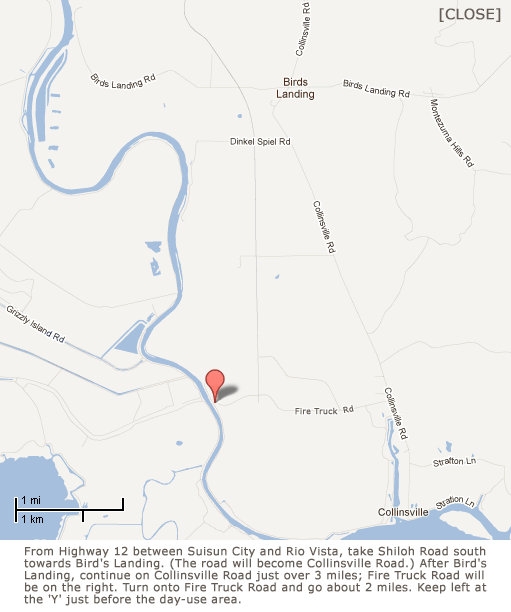
DWR Collinsville Day-Use Area
Fire Truck Rd
Collinsville, CA 94585
THIS LOCATION IS CURRENTLY CLOSED DUE TO FLOODING.
Located on the eastern side of Montezuma Slough in the Suisun Marsh, this
day-use area has a fishing pier, picnic tables, and a short trail along the levee. You can walk down the trail and view the Suisun Marsh Salinity Control Gates.
[Photos]
|
 |
Decker Island Wildlife Area
Off of Highway 160.
Access by boat only.
Located between the Sacramento River and Horseshoe Bend about 3 miles downriver from Rio Vista, Decker Island was formed
in the early 20th century when dredging residue was heaped onto existing wetlands. The Department of Fish & Game owns the top 34 acres of the
470-acre tract, and undertook a restoration program in the early 2000s. Please click on link for more information and map.
[Photos]
|
 |
George Miller, Jr Memorial Bridge (Benicia-Martinez Bridge)
Pedestrian/Bicycle Path
Interstate 680 (Southbound)
Benicia, CA
94510
Closing a gap in the regional San Francisco Bay Trail and Bay Area
Ridge Trail, the new pathway allows bicyclists and pedestrians to
cross the Carquinez Strait between Contra Costa and Solano counties,
and provides a spectacular view of the Suisun Bay.
[Photos]
|
 |
Glen Cove Waterfront Park
Whitesides Dr off of Regatta Dr
Vallejo, CA 94591
Three regional trails come together at Glen Cove Park: the Bay Area
Ridge Trail, the San Francisco Bay Trail, and the Great California Delta Trail. The scenic views of the Carquinez Strait can be enjoyed during walks, bike rides, picnics, or while relaxing on the park's benches. The 15-acre park also provides a stairway access down to the waterfront.
[Photos]
|
 |
Grizzly Island State Wildlife Area
Off State Highway 12
On Grizzly Island Rd
Suisun City, CA 94585
Located in the heart of the Suisun Marsh, the largest contiguous
estuarine marsh in the United States, Grizzly Island Wildlife Area
is a 14,300-acre wildlife area with 75 miles of roads and trails
attracts nature lovers, anglers, hunters, and other outdoor
enthusiasts year-round.
[Photos]
|
 |
Hill Slough Wildlife Area
Grizzly Island Rd south of Highway 12
South of Suisun City
High Slough Wildlife Area consists of 1,723 acres of
salt tidal marsh, managed marshes, sloughs and upland grassland. The
area supports a wide variety of waterfowl, including pintail,
mallard, shoveler, green-winged teal, and wigeon. Raptors such as
northern harriers, white-tailed kites, kestrels, and red-tailed
hawks can be seen hunting the grasslands. Mammals including
raccoons, jackrabbits, and voles make their homes here and may
provide a meal for the coyotes that hunt and live in the wildlife
area.
[Photos]
|
 |
Hunter Hill Safety Roadside Rest Area
Westbound Interstate 80 above Vallejo
Suisun City, CA 94589
Managed by the CA Department of Transportation, this park-like setting overlooking Vallejo includes eight picnic tables and designated pet-walk areas. The rest area also showcases the Blue Star Memorial Highway Monument and a topographical panoramic display of Vallejo and the San Francisco Bay Area.
[Photos]
|
 |
Jepson Prairie Preserve
Cook Ln off Highway 113 South
12 miles south of Dixon
Jepson Prairie Preserve contains some of the best examples of the
land and habitat that once dotted California’s Central Valley. Some
of the world’s most endangered plant and animal species reside in
the Preserve, and it is also well-known to wildflower enthusiasts
for its springtime displays.
[Photos]
|
 |
Lagoon Valley / Peña Adobe Regional Park
Off Interstate 80
Between Fairfield and Vacaville
In 1845, Governor Pío Pico granted Juan Felipe Peña and Manuel Cabeza Vaca the site where the Peña
Adobe still stands, and it is still owned by the descendants of their families. The park includes barbecue areas,
[Photos]
|
 |
Lake Herman Recreation Area
Lake Herman Rd
Benicia, CA 94510
Lake Herman Recreation Area is a 577-acre park located about 4 miles north of
Benicia. Sulfur Springs Creek flows into the 50-acre reservoir which
contains drinking water for the City of Benicia.
Activities include fishing, hiking, and picnicking but no water
sports. During dry times of the year, trails connect to residential
areas within Benicia as well as to a segment of the Bay Area Ridge
Trail.
[Photos]
|
 |
Lake Solano County Park
8685 Pleasants Valley Rd
Winters, CA 95694
Lake Solano is known as one of the best fly fishing spots in the
Sacramento Valley, but there’s plenty for boaters, swimmers, hikers,
bikers, nature lovers, campers, and picnickers to do also. Lake
Solano was formed by the Putah Diversion Dam and also offers 90 campsites.
[Photos]
|
 |
Levee Walking Trail
Bayshore Rd
Benicia, CA 94510
The Levee Walking
Trail in Benicia is a 3/4-mile out-and-back pedestrian path. The
trail runs along the marsh shoreline of Suisun Bay beginning under
the Benicia-Martinez Bridges. There are two picnic areas, one at the
beginning of the trail and another at the terminus by the mouth of
Sulphur Springs Creek. To access the Levee Walking Trail from I-680
North-bound, exit at Bayshore
Road in Benicia and turn right. From I-680 South-bound, exit and
turn right onto Industrial Way. Then turn left onto Park Road and
left again onto Bayshore Road. Continue to follow the road toward
the bridge. A Public Access sign points to parking and a Pedestrian
Access sign indicates the opening to the trailhead.
[Photos]
|
 |
Lynch Canyon
3100
Lynch Rd
Vallejo, CA
Lynch Canyon is the northeastern portal between the Greater Bay Area
and the Central Valley. Grasslands, oak groves, riparian woodlands,
and wetland meadows provide shelter and forage for deer, fox,
bobcat, waterfowl, and many raptors. The 900-foot ridges offer
panoramic views extending from the Coast Ranges to San Francisco Bay
and across the Delta to the Sierra Nevada.
[Photos]
|
 |
Mare Island Shoreline Heritage Preserve
South end of
Railroad Ave, Mare Island
Vallejo, CA 94592
THIS LOCATION IS CURRENTLY CLOSED DUE TO LEGAL ISSUES.
The Mare Island Shoreline Heritage Preserve
is a 215-acre parcel located at the south end of Mare Island on land
that formerly served as the U.S. Navy's first Naval Ammunition
Depot. In 2002, the property was designated by the California
Legislature as a historic and nature park. The first phase of the
regional park is now open for guided tours and includes the oldest
naval cemetery in the Pacific and sweeping views of the Mare Island
Strait, the Carquinez Strait, and San Pablo Bay. Features include
the Mare Island San Pablo Bay Walking Trail.
[Photos]
|
 |
Miner Slough Wildlife Area
West of Highway 84 on
Prospect Island
Access by boat only.
Please click on link for more information and map.
[Photos]
|
 |
Peytonia Slough Ecological Reserve
South end of Kellogg St near the boat launch ramp
Suisun City, CA 94585
Managed by the CA Department of Fish & Game, this 206-acre parcel is
a snapshot of the Suisun Marsh. Gravelled walking trails lead you
through marsh land that is the habitat of unique plants, animals,
and over 200 species of birds.
[Photos]
|
 |
Putah Creek Wildlife Area
Day-use Fee Required
State Highway 128, 7 miles west of the town of Winters
Located near the Monticello Dam where Cold Creek meets Putah Creek, the
area offers hikers 670 acres in their natural state with an
abundance of wildlife and native plants. The trails contain very steep
sections, but the views are magnificent. Fishing access points are
located along the creek. No overnight camping is allowed.
[Photos]
|
 |
Rio Vista Waterfront
Promenade
North Front St
Rio Vista, CA 94571
This park features
a beautiful promenade along the Sacramento River water front and is
popular with walkers, photographers, dog lovers, joggers and fishing
enthusiasts. The area features a nearby fishing dock, a fish
cleaning station, picnic tables, and BBQs. From Highway 12
Eastbound, take the Front Street exit just before crossing the Rio
Vista Bridge. Turn left at the stop sign onto Front Street. Turn
right into the Waterfront Promenade parking lot just before going
under the bridge.
[Photos]
|
 |
Rockville Hills Regional Park
Rockville Rd
Fairfield, CA 94534
Day Pass Required
The park encompasses nearly 600 acres of grasslands and oak
woodlands. Hikers, mountain bikers and families enjoy native trees
and plants, rock formations, over 30 miles of tracks and trails, and
picnic areas.
[Photos]
|
 |
Rush Ranch
3521 Grizzly Island Rd
Suisun City, CA 94585
Rush Ranch is a 2,070-acre open space and operating cattle ranch located in the Potrero Hills
along Grizzly Island Road in the Suisun Marsh. It features a visitor
center, blacksmith shop, historical ranching equipment, hiking
trails, and birding opportunities.
[Photos]
|
 |
Sandy Beach Park
2333 Beach Dr
Rio Vista, CA 94571
Sandy Beach Park sits on the Sacramento River at Rio Vista. Open
year round, the park offers a 24-hour boat-launching ramp, camp
sites, picnic grounds, a hiking trail, miles of country roads for
bicycling and a sandy beach stretching for over half a mile. Sandy
Beach is also a popular venue for windsurfing. Because of strong
river currents and sudden drop-offs, swimming is not permitted.
[Photos]
|
 |
San Pablo Bay National Wildlife Refuge
'A' St west of Azuar Ave
Mare Island
Vallejo, CA 94592
The refuge habitats include open bay waters, salt marsh, intertidal
mudflats, upland habitat and restored wetlands. The refuge provides
vital habitat for threatened and endangered species, as well as
millions of migrating waterfowl, shorebirds and local resident
wildlife. Activities include wildlife observation and photography,
hiking, and fishing.
[Photos]
|
 |
Stebbins Cold Canyon Reserve
Day-use Fee Requested
State Highway 128, 7 miles west of the town of Winters, just east of
Monticello Dam
The reserve is part of the University of California Natural Reserve System
whose natural lands are protected and managed for academic and
public uses. It is located within the Putah Creek State Wildlife
Area and contains diverse plant and animal communities in a variety
of habitats. Trails range from moderately easy to strenuously
difficult.
[Photos]
|
 |
Suisun Bay
Vista Point
I-680 at Lake Herman Rd
Benicia, CA 94510
The Suisun Bay Vista Point overlooks Suisun Bay and the National
Defense Reserve Fleet, also known as the "Mothball Fleet." Once on
stand-by for national emergencies, the fleet numbered over 300
vessels. However, because these ships now are decaying, a
dismantling program has begun.
[Photos]
|
 |
Suisun City Waterfront
800 Kellogg St
Suisun City, CA 94585
The Suisun Channel provides deep-water access for most recreational
boats to the waterways of the California Delta and San Francisco
Bay. Enjoy boating, cruising, water skiing, jet skiing, and
kayaking. The slough winds through the Suisun Marsh, largest
contiguous estuarine marsh in the United States.
[Photos]
|
 |
Suisun Marsh
Environmental Services Office -- California
Department of Water Resources
Stretching over 116,000 acres, Suisun Marsh encompasses more than
10% of California's
remaining natural wetlands. It is home to more than 221 bird
species, 45 animal species, 16 different reptilian and amphibian
species, and more than 40 fish species. The Marsh is ideally suited
for wildlife viewing, hiking, canoeing, and other recreation
opportunities.
[Photos]
|
 |
Suisun Valley
Nestled
between two coastal mountain ranges, and situated midway between San
Francisco and Sacramento, Suisun Valley
is an agricultural area of close to 10,000 acres. The view includes
vineyards, orchards, and plowed fields, and visitors can drop in to
premium wineries, farm-fresh produce stands, and quaint eateries.
The driving time from either San Francisco or Sacramento is
approximately 45 minutes. Exit I-80 in Fairfield onto Suisun Valley
Road or Abernathy Road.
[Photos]
|
 |
Vallejo Marina & Waterfront Promenade
Mare Island Way
Vallejo, CA 94590
The Vallejo Waterfront is home to the
Ferry Building, the municipal marina and a
continuous 1 mile promenade along Mare Island Strait providing open space and park
areas for walking, biking and picnicking,
from Solano Avenue on the south to the Mare Island Causeway on the
north.
[Photos]
|
 |
White Slough
Access by bike path between Sacramento St and
Sonoma Blvd
Vallejo, CA 94590
White Slough is a detention basin for overflow water from the Napa River. It is an important part of the flyway and one of the best birding locations in Solano County. The southern portion of White Slough covers 125 acres directly south of Highway 37 in Vallejo between Sacramento Street and Sonoma Boulevard. A segment of the San Francisco Bay Trail parallels Highway 37 along the perimeter of the slough.
[Photos]
|
 |
|
|
|